A wildfire in Washington State less than 20 kilometres from the Canada-U.S.A. border has grown in size and is still considered out of control, but still isn’t an immediate threat to Canadian residents.
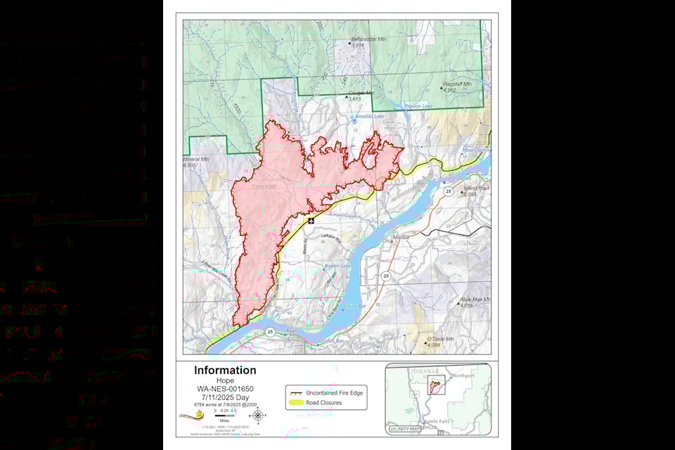
As of Friday, the Hope Fire had grown to 2,280 hectares (5,634 acres), with 476 personnel attacking it, but was still at zero per cent contained.
Also as of Friday, command of the fire response turned to Northwest Team 8, a Complex Incident Management Team, from Northeast Washington Team 3.
In a briefing video sent on Friday morning, Ryan Sullivan, Operations Sections Chief for Northwest Team 8, outlined the progress and strategy going forward. Most of the work is being done to protect structures and private land on the east end of the fire, he said.
“We’ve been doing great work in this part, protecting structures, private land and stakeholders’ property,” he said.
Work is also turning to the southern and western flank, with crews attacking the fire as directly as possible and moving northward, said Sullivan. Multiple fire crew divisions have been established around the entirety of the fire, going as tight to the fire’s edge to push it back and minimize the number of burned hectares.
Crews are also receiving assistance from B.C. Wildfire Service. As of Tuesday, a social medi post stated that it has also deployed airtankers to support wildfire suppression efforts.
“We are aware of a wildfire in Washington State, south of Highway 3 between Christina Lake and Trail,” the post stated. “At this time there is no threat to the Canada-US border.”
The Regional District of Kootenay Boundary announced in a news release it has activated its emergency operations centre to a level 1 to monitor the fire.
“We are activating out of an abundance of caution and to continue to monitor the fire,” said Mark Stephens, EOC Director for the RDKB. “With wildfire season here, we encourage residents to plan for emergencies, such as create Grab and Go kits.”
Residents are also reminded to sign up for the RDKB's free emergency alert system and to plan for an emergency.
Residents can monitor the situation via @RDKB_Emergency Twitter Feed for reliable updates, as well as BC Wildfire Service’s website for wildfire maps: https://wildfiresituation.nrs.gov.bc.ca/map
People can also monitor if wildfires are affecting highway closures at https://www.drivebc.ca/
Level 3 Evacuations remain in effect around the fire. Evacuation and road closure information is available on the Stevens County Emergency Management Facebook page https://www.facebook.com/stevenscountyem/.
*****
An update from Northeast Washington Fire Information on Wednesday morning stated firelines along the south end of the fire near China Bend on the Columbia River were successfully held as of Tuesday night, with the addition of an approximately 15-acre (six hectares) spot fire that crews were able to put a fireline around connecting it with the main fireline.
Fire continued to burn in timber, brush and grass in the Flat Creek drainage near Lael Road and to the north and east toward Flagstaff Mountain.
*****
A news release on Tuesday stated structure protection firefighters were assessing structures and working with heavy equipment providing protection where possible, while providing for firefighter safety.
On the south end of the fire, crews focused on reinforcing dozer and hand lines constructed the previous day.
On the west side of the fire, there was minimal fire activity and crews assessed containment options. On the east and north sides, fire activity increased when afternoon winds increased and shifted directions. Firefighters and equipment (dozers) successfully installed an indirect fireline to the north by widening and improving existing roads south of Pepoon and Ansaldo Lakes.


